|
LAFOURCHE PARISH GAME AND FISH COMMISSION
Ecological Issues
| ||||
|
Introduction
The Lake Fields/Lake Long Game and Fish Preserve (Preserve) as well as other Mississippi River deltaic plain wetlands have been heavily impacted by human activities dating back to the early 1800s. The purpose of this section will be to discuss habitat, water quality, and biological issues within the Preserve. A secondary objective is to illustrate that local habitat changes and wetland losses are rarely the result of a single factor but due to the cumulative effects of natural factors and human-induced modifications that may be local or geographically far removed. Local habitat modifications that have directly impacted the Preserve include major transportation or drainage canals such as Company Canal and Hollywood Canal, drainage basin reclamation projects, petroleum related activities, and upper Bayou Folse watershed drainage improvements. Habitat modifications outside the Preserve and watershed that have peripherally impacted the Preserve included the dam across Bayou Lafourche at the Mississippi River, levees along the Mississippi River, the Gulf Intracoastal Waterway (GIWW), the Houma Navigation Channel, and the Company Canal Weir. The Third Delta Conveyance Channel as proposed could result in significant impacts to the Preserve. Other proposed coastal restoration, transportation, or hurricane protection projects may also impact the Preserve in the future. Major current and potential habitat, water quality, and biological issues within the Preserve include the following:
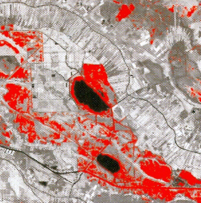
Fresh marshes similar to those within the Preserve have been subjected to the highest land loss rates in coastal Louisiana. There are no published estimates of marsh loss within the Preserve although estimates of marsh loss are available regionally or basin-wide and the COAST 2050 report provides some relevant data. About 20% of coastal wetlands have been lost in the Mississippi River deltaic plain. The projected land loss by the year 2050 in the Fields Swamp unit (i.e., the area bounded by Thibodaux, Bayou Lafourche, and the Bayou Blue ridge) is 3,210 acres of fresh marsh, or 15.5% of the total. A portion of a map (Southeast Louisiana Land Loss, Map ID=USGS-NWRC- 2005-16-0001) projecting land loss through 2050 shows that Lake Fields proper will expand significantly and encompass an increasingly greater proportion of the Preserve (see figure below).
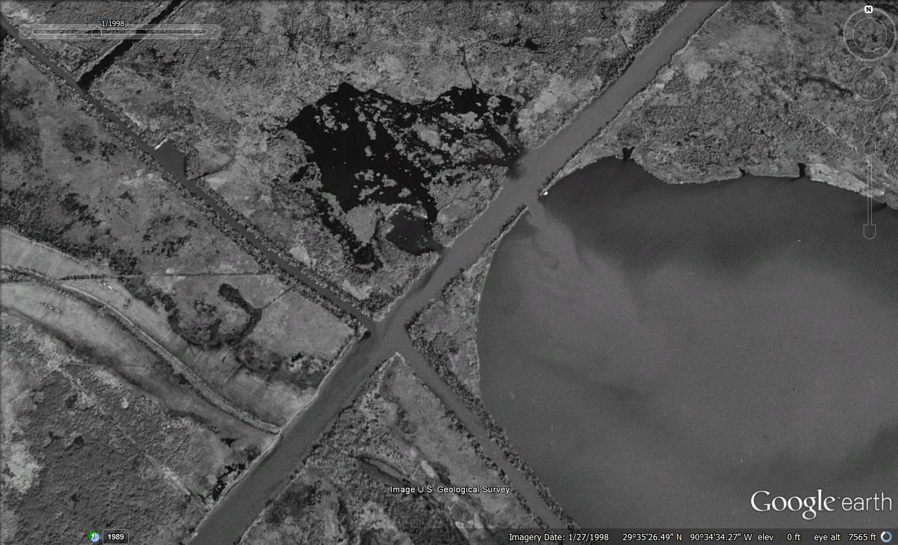
Factors such as subsidence, sea level rise, freshwater and sediment deprivation, oil exploration and transportation canals, saltwater intrusion, shoreline erosion, and herbivory are all contributors to wetland loss in coastal Louisiana. Separating the individual influences of each of these factors on wetland loss in a localized area such as the Preserve is extremely difficult if not impossible. However, a brief discussion follows on marsh loss processes within the Preserve and in fresh marshes in general. Fresh marshes have soft and poorly consolidated substrates and are vulnerable to wake or wave erosion and to marine tidal processes; subsidence (currently 1.1-2.0 feet per century), canals, and cuts across natural ridges and shorelines further exacerbate fresh marsh loss rates. The influx of higher salinity water and related sulfide formation results in extensive destruction of fresh marsh vegetation. However, more salt tolerant vegetation generally does not become established because these vegetation types usually only repopulate in areas of firm substrate which are not prevalent in fresh marsh habitats. The resultant barren mud flats are usually converted to open ponds when exposed to tidal processes or wave action when breaches occur in the skeletal framework of natural ridges and lake rims. The loss of sediment and freshwater input from the Mississippi River and Bayou Lafourche because of the construction of Mississippi River levees after the historic 1927 flood and the Bayou Lafourche dam in the early 1900s had significant adverse impacts on upper Terrebonne Bay estuary wetlands. These wetlands were unable to compensate for natural land subsidence and were subjected to increased salt water intrusion. Many wetland scientists believe that the loss of sediments and freshwater from periodic Mississippi River overflows is the single largest contributor to marsh loss. Other man-induced modifications directly resulted in marsh loss within the Preserve. The Company Canal and other smaller canals were dug within the Preserve. A 640 acre reclamation project formerly known as Smithport Plantation was partially within the historic meander line of Lake Fields on the southwest side of Company Canal. Eutrophication and Water Quality Degradation Eutrophication, the natural or artificial addition of nutrients to water bodies, has been greatly accelerated by human activities. Many water bodies in the upper Terrebonne estuary are eutrophic and characterized by frequent algal blooms and periodic episodes of low dissolved oxygen. The primary source of nutrients in the Lake Fields/Lake Long basin is from runoff from pastures and farms, permitted discharges, and residential runoff from the upper watershed via Bayou Folse and the Houma via Hollywood Canal. A large portion of the Lake Fields/Lake Long basin is reclaimed wetlands under forced drainage and pump stations. The U.S. Army Corps of Engineers evaluated water quality data throughout the Terrebonne Basin and observed that in coastal bayous 89% of their linear distribution had water quality problems caused by oil and grease, 72% had problems caused by organic enrichment/low dissolved oxygen, and 69% had problems caused by fecal coliform levels. The LA Department of Environmental Quality recently conducted a water quality study of the Bayou Folse watershed. A calibrated water quality model for the watershed was developed and projections were modeled to quantify the non-point source load reductions which would be necessary for Bayou Folse to comply with established water quality standards. Results suggested that Bayou Folse did not meet the 5.0 mg/l standard for dissolved oxygen, and that even a 90% reduction in non-point source pollution would not result in achievement of the 5.0 mg/l criteria. Hydrological Alterations Pronounced alterations in the upper Lake Fields drainage basin and watershed hydrology resulted in an increased inflow into Lake Fields of nutrient-laden, degraded water from the upper watershed. This inflow, which had become increasingly obvious by the 1960s, was associated with several specific physical watershed modifications. The first was the erosion / subsidence of the west bank of lower Bayou Folse, which created large openings into Lake Fields. The second was the decrease in water depths of Bayou Folse due to the accumulation of sediments and organic materials. Finally, there were unforeseen, adverse impacts associated with an upper Bayou Folse watershed drainage project beginning during the late-1960s by the U.S. Department of Agriculture Soil Conservation Service. The project included clearing and deepening of upper Bayou Folse, pump stations, diverting water from the 40-arpent canal (which formerly bypassed Lake Fields and emptied into Company Canal) into Bayou Folse, other drainage improvements, and a substantial increase in watershed drainage area. As a result of these modifications, the flow capacity in upper and mid-Bayou Folse was increased and more turbid, nutrient-enriched water originating from permitted discharges and runoff from cattle pastures, farm lands, and residential areas entered the Bayou. However, the shallow lower Bayou Folse was unable to accommodate this increased flow capacity and an increased proportion of the upper Bayou Folse water flow was diverted through Commercial Canal into Bayou Dumar and eventually into northern Lake Fields or directly into Lake Fields via the discontinuous western shoreline of lower Bayou Folse. The increased inflow of nutrient-laden, poor quality water from the upper watershed resulted in immediate and long-term adverse impacts on water quality and physical habitats in Lake Fields and surrounding marsh. The inflow of degraded into Lake Fields is illustrated in the following figure. Water in Lake Fields became more turbid and nutrient enriched and submergent vegetation dramatically declined. Shoreline erosion also accelerated without the wave-reduction cushion provided by dense growths of submergent and emergent vegetation.
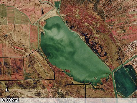
Although Lake Long has relatively profuse submergent vegetation and viable sport fish and waterfowl populations, the opening from Company Canal has increased in size and the lake is receiving an increased inflow of turbid, nutrient-enriched water from the upper watershed. Submergent aguatic vegetation has declined in recent years. This following figure illustrates the inflow of turbid water from Company Canal.
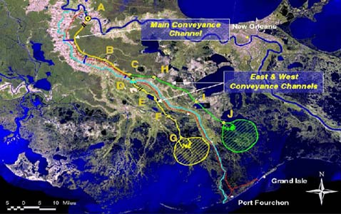
Hollywood Canal, which originates just north of Houma, is a source of nutrient-laden, degraded water originating from residental areas. Hollywood Canal enters the Preserve just south of Lake Long; fortunately, only a small percentage of the water flow enters Lake Long. Hydrological modifications associated with hurricane or flood protection projects, natural waterway modifications, and transportation channels outside the Preserve boundaries have also impacted the Preserve by reducing freshwater input or facilitating salt water intrusion (see the following section). Salt Water Intrusion The Preserve is a freshwater ecosystem, although salt water intrusion may occur seasonally during periods of low rainfall and/or low Atchafalaya River discharges. Salt water intrusion into the upper Terrebonne estuary has been greatly accelerated by man-induced habitat modifications and subsidence. Several projects have reduced freshwater input or increased saltwater intrusion into the Preserve. Construction of the Bayou Lafourche dam at its junction with the Mississippi River in 1904 and of large continuous levees along the Mississippi River after the massive 1927 flood eliminated periodic overflows of freshwater and sediment into the Lake Fields basin. The Houma Navigational Channel (1962), GIWW (around 1949), Company Canal (mid 1800s), and smaller oil location canals have provided an avenue for higher salinity waters from the Gulf to enter the Preserve. Fortunately, recent hydrological data has shown that freshwater inflows from the Atchafalaya River (via the Avoca Island Cutoff Channel) eastward through the GIWW has increased in recent years; this increase was attributed to delta growth and increased water surface elevations at the confluence of the Atchafalaya River and the Avoca Island Cutoff Channel. In addition, several projects have reduced or will reduce the impact of salinity intrusion into the Preserve. In 2003, a saltwater control structure was constructed in Company Canal south of Lake Fields because of saltwater intrusion into Bayou Lafourche via Company Canal and the resultant impact on drinking water supplies. The control structure was periodically closed during periods of higher salinities,to prevent upstream salt water intrusion. However, the weir was removed in 2013 to Bayou Lafourche above Company Canal and this structure will no longer block salt water from the south. The authorized Bayou Lafourche Freshwater Introduction project will increase the Mississippi River diversion flow from 200 cfs to 2,000 cfs; freshwater inflow into Company Canal from Bayou Lafourche is expected to increase. In addition, there are several proposed hurricane protection or coastal restoration projects that may impact the Preserve ecosystem in the future. The Morganza To The Gulf Hurricane Protection Levee system (which includes the Houma Navigation Locks) will reduce saltwater intrusion into the upper Terrebonne estuary and the Preserve. Exotic Species Exotic (non-native) species may be introduced accidentally or intentionally and may pose serious threats to fresh marsh systems. Some exotic species are considered invasive because they flourish in their new habitats in the absence of competitors or other limiting factors to population growth that were formerly present within their native range or habitat. Once established, invasive species can be very difficult or impossible to control or eradicate. The Barataria-Terrebonne National Estuary Program (BTNEP) sponsored a basin-wide invasive species rapid assessment in August 2008, and samples were taken within the Preserve. The most common and abundant invasive species in the Preserve are plants. Some exotic aquatic and terrestrial plants that were documented within the Preserve during the BTNEP assessment included alligator weed (Alternanthera philoxeroides), wild taro (Colocasia esculenta), water hyacinth (Eichhornia crassipes), hydrilla (Hydrilla verticallata), torpedo grass (Panicum repens), common reed (Phragmites australis), water lettuce (Pistia stratioides), common salvinia (Salvinia minima), and Chinese tallow tree (Sapium sefierum). Once established, exotic plants may out-compete native vegetation and form mono-cultures in previously diverse habitats. Exotic plants may impede water flow, interfere with recreational activities such as fishing, and block navigation. Dense mats of floating or submerged invasive plants may also impact food availability, sunlight penetration, dissolved oxygen, and other aspects of water quality. Of the exotic aquatic plants currently documented in the Preserve, hydrilla and water hyacinth probably have the greatest potential to impede navigation and impede recreational activities. The terrestrial Chinese tallow tree is a very hardy and prolific species that out competes other vegetation and has little or no wildlife value. This species is considered to be a serious threat along the Louisiana coast. Giant salvinia (Salvinia molesta ) has been recorded several miles away in the GIWW; this species is potentially the most noxious aquatic plant species because it may double its biomass in as little as one week. Apple snails, an invasive aquatic species from South America, was first found in Louisiana in 2006 and have been found in the Preserve. Apple snails are very prolific and may damage vegetation because of their large size and their individual consumption of plant material. The nutria (Myocaster coypus) is a common mammal exotic species in the preserve. The nutria is a voracious herbivore and in areas with high densities may consume marsh plants down to the roots, which exposes the soil to erosion. Nutria densities have been linked to marsh loss in some coastal areas. Nutria populations have increased in recent years because of the decline in trapping associated with the decreasing fur demand. Exotic fishes collected or observed to date within the Preserve include the silver carp (Hypophthalmichthys molitrix) and common carp (Cyprinus carpio), but additional exotic fishes will probably eventually inhabit the Preserve. The Rio Grande cichlid (Cichlasoma cyanoguttatum) was recently collected in upper Bayou Folse north of the Preserve. Other exotic fishes such as grass carp (Ctenopharyngodon idella), black carp ( Mylopharyngodon piceus, and bighead carp (Hypophthalmichthys nobilis) have been collected in the Atchafalaya Basin and the Mississippi River, both of which are connected via various waterways to the Preserve. In Bayou Lafourche, several exotic fishes such as pacu (Piaractus brachypomum) have also been collected. Proposed Local Projects The Third Delta Conveyance Channel (TDCC) is a component of the Coast 2050 coastal restoration program. The TDCC as proposed aligns a large channel for conveyance of Mississippi River water and sediments leading to two subdeltas in the Barataria and Terrebonne Bay estuaries east and west of Golden Meadow. The conveyance channel would leave the Mississippi River along its west bank a short distance downstream from the Sunshine Bridge. The main channel would parallel Bayou Lafourche for approximately 30 miles to near Lake Boeuf, where it would bifurcate into two channels east and west of the Bayou. The conveyance channels would be flanked by guide levees to prevent flooding into adjacent areas. The average footprint of the forks of the conveyance channel would be approximately 1000 feet, and include the channel and a 100 foot buffer and 10 foot high levee on each side. The TDCC will destroy freshwater swamp and marsh habitats in the upper estuary but accrue benefits further downstream through the development of subdelta lobes. Gagliano and van Beek (1998) estimated that each subdelta would be from 80-100 square miles each under optimum conditions and would require 50-100 years to fully develop. At least one of the proposed alignments (see following figure) of the west fork of the TDCC conveyance channel would cut across the Preserve proposed by the North Lafourche Levee District. In addition to the direct physical disruption of fresh marsh habitats within the Preserve, the physical barrier presented by the borrow pits, levees, and conveyance channel would block access across the Preserve. Historic hydrology of the Lake Fields basin would also be disrupted.
The impacts of the proposed hurricane protection levees and other flood control as proposed by the North Lafourche Levee District and in the Morganza to the Gulf federal project near the Preserve have not been evaluated. Proposed Levee District modifications near the Preserve include: improvement of levees from the Butch Hill pump station to the existing station in Bayou Folse and along Bayou Folse, Commercial Canal, Company Canal (Smithport side), and Bayou Dumar; installation of a new pump station / canal closure across Bayou Dumar just beyond the intersection of Bayou Dumar and Jim Knight Canal; construction of a levee along the north side of Jim Knight Canal from Bayou Dumar to Hwy. 182; and, installation of deployable flood gates at all culverts crossing Hwy. 182. The Morganza to the Gulf Project includes levees to the south of the GIWW and locks on coastal bayous and navigation channels. |