|
LAFOURCHE PARISH GAME AND FISH COMMISSION
Lake
Fields Terraces Proposal
| |
|
Introduction
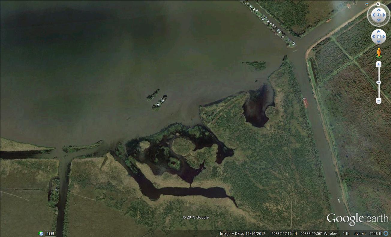
The Lake Fields ecosystem was significantly altered by reclamation projects in the early 1900s and a upper Bayou Folse drainage improvement project by the U. S. Soil Conservation Service; the original restoration plan provides a more detailed perspective on the decline of Lake Fields and recommendations to restore the Lake. The orignal plan involved two independent but complimentary components: redirection of Bayou Folse water into Company Canal rather than through the Lake, and creation of terraces around the Lake Fields shoreline. The North Lafourche Levee District recently completed a cooperative mitigation project in Lake Fields and lower Bayou Folse that was largely based upon the Commission's restoration plan. One component of the Levee District's project involved the creation of shoreline terraces along lower Bayou Folse and the northeast shoreline of Lake Fields. Lake Fields is approximately 2,000 acres in size and has a long north-south fetch. Unfortunately, this subjects the northern and southern shorelines to the strong seasonal prevailing winds -- north during the late fall/winter and southeast the remainder of the year. The Lake is surrounded by primarily "flotant" fresh marsh that is very susceptible to wave-induced erosion once the shoreline rim deteriorates. Shoreline erosion in Lake Fields has accelerated in recent years due to several factors, including natural subsidence and loss of the wave-dampening cushion provided by dense growths of submersed and emergent vegetation that formerly were present in Lake Fields. The loss of aquatic vegetation in Lake Fields was associated with an increased influx of turbid, nutrient-laden water from the upper Bayou Folse watershed which was attributed to an upper Bayou Folse watershed drainage project beginning during the late-1960s by the U.S. Department of Agriculture Soil Conservation Service. The project included clearing and deepening of upper Bayou Folse, pump stations, other drainage improvements, and a substantial increase in watershed drainage area. As a result of these modifications, the flow capacity in upper and mid-Bayou Folse was increased and more turbid, nutrient-enriched water originating from cattle pasture, farm land, and residential area runoff entered the bayou. However, the flow capacity of lower Bayou Folse (which paralleled Lake Fields before emptying into Company Canal) was decreased significantly because of decreased water depths due to the accumulation of sediments and organic materials. Consequently, an increased proportion of degraded, upper Bayou Folse water flow was diverted into northern Lake Fields via Commercial Canal/Bayou Dumar. Commercial Canal connects Bayou Folse and Bayou Dumar just north of Lake Fields and Bayou Dumar empties into Lake Fields. A dramatic decline in submergent aquatic plants occurred as Lake Fields became more turbid and nutrient enriched. With the creation of shoreline terraces along the northern rim of Lake Fields, the southern shoreline of Lake Fields is currently the most critical section. A significant portion of the southern lake rim has deteriorated which has exposed the fragile interior wetlands to wave action and tidal processes (see following figure).
Earthen terraces are a viable, large scale marsh restoration tool in Louisiana coastal waters. Terraces are typically arranged in an alternating pattern at 30-degree angles and placed in a "V" shape (referred to as a "duck wing terrace") so that regardless of the wind direction, calm water will exist on the downwind side of the terrace. However, terraces may also be placed parallel to the shoreline or over partially submerged or totally submerged shorelines. Terraces are usually about four times wider at the base than at the top, two feet or more above water level, and planted with native vegetation to reduce erosion. The immediate and primary benefit of earthern terraces is a reduction in wave action and associated shoreline erosion in shallow littoral areas. Shallow littoral areas on the landward side of the terraces also provide optimum conditions for submergent and emergent vegetation. Increased habitat diversity would result from the creation of high vegetated terraces, edge habitat, and areas with increased water depths from dredging of spoil material. Goals The goals of the Lake Fields terrace project are to: a) reduce wave action and shoreline erosion; b) improve water quality; c) increase emergent and submergent vegetation; and, d) increase habitat diversity. Additionally, marsh creation with earthen terraces is easily quantified and qualifies as a mitigation credit. Project Plans Terraces should be constructed along the historic southeast lake shoreline using either a bucket dredge or marsh buggy excavator. There are several options for orientation (parallel or over the historic shoreline, alternating pattern at 30-degree angles, etc.); orientation will be determined later. Terraces are usually about four times wider at the base than at the top and two feet or more above water level. An engineering pre-assessment will be conducted to provide the best options for a successful project. All terraces will be planted with native vegetation to reduce erosion. A monitoring program of vegetation and water quality will be implemented. |